September 13, 2009 Midland, MI
I love the familiarity of attending church. In whatever city or country it may be, there are some things that always seem the same. The young men in white shirts and ties at the front of the chapel before the meeting trying to determine who is there and if they will need to ask more people to help with the sacrament. A group of young women at the back of the chapel chatting together about whatever young women chat and giggle about. An older sister moving in and out of the pews handing out ward newsletters to those who had arrived early and taken their seats. A mother entering the chapel followed by two young girls in dresses with bows in their hair, finding their way to a place on the back row. Individuals greeting each other as they find their way to an empty bench, people genuinely happy to see each other and to be together.
Somehow I want to believe that heaven will be more about greeting and chatting and finding joy in our personal interactions, than about sitting quietly listening to heavenly prelude. Yes, there is a time for quiet reverence and introspection, and the chapel before church may be one of them, but isn't there also something holy in a people whose hearts are intertwined, who share their lives with each other, who inquire about and look after each other as God would if He were here? Even if there is a bit of noise arising from their joy at meeting together again? I think God will tolerate a little noisy reverence among his children.
Sunday, September 13, 2009


Friday, July 17, 2009
Boulder Mountain
July 17, 2009 Boulder Mountain
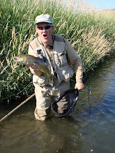
Some of the crew were pretty worn out after the activities of the last few days, so instead of the hike into Calf Creek Falls, we decided a scenic drive up the Hell's Backbone road between Escalante and Boulder with a picnic up high on Boulder Mountain and a couple fishing stops would be a nice change of pace. The first fishing stop was great (Pine Creek at the lower entrance to The Box). A beautiful little stream full of nice sized little brown trout eager to take a fly. In some places the stream runs along red slickrock faces - pretty cool.
 One of many Pine Creek browns
 First cast in Pine Creek
 Small Pine Creek Cutthroat
 Jess still knows how to use a fly rod
Some of the crew were pretty worn out after the activities of the last few days, so instead of the hike into Calf Creek Falls, we decided a scenic drive up the Hell's Backbone road between Escalante and Boulder with a picnic up high on Boulder Mountain and a couple fishing stops would be a nice change of pace. The first fishing stop was great (Pine Creek at the lower entrance to The Box). A beautiful little stream full of nice sized little brown trout eager to take a fly. In some places the stream runs along red slickrock faces - pretty cool.
 One of many Pine Creek browns
 First cast in Pine Creek
We continued up the road where I was hopeful of stopping alongside this creek a few miles further up the mountain for a picnic and a bit more fishing. The car decided otherwise, as we started to overheat and boil over pretty badly when we were just short of the top. After a wait for the engine to cool a little, I turned around and we headed back to Escalante. The only shop in town did a quick check and found the radiator cap didn't hold pressure, but nothing else wrong. Only cost the cost of the new cap. Thanks guys! But I lost a little faith in the old minivan and was a little unsure of going way off the beaten path, so we stuck to the main highway on our way to Capitol Reef. Still an amazingly beautiful drive (I should have stopped to fish Calf Creek though! Another reason to go back some time)
We stayed the night in Bicknell a little ways from Capitol Reef because there was a hotel there with a good deal on a family room (Aquarius Inn, two rooms, kitchen, hide-a-bed for $79/night). I had a fishing license which could do with a little more use and a couple hours of free time, so I found another Pine Creek which appeared to be not too far from Bicknell and took off with Jessica, who was excited to accompany me. With evening time running short, gravel roads became 60 mph highways as I rushed to try and find the creek. It appeared I guessed correctly at all the road forks, as we looked ahead and saw the road approaching what appeared to be a creek in the valley bottom. Or did I find the right stream? It looked more like a small ditch with a little water running beside the road! Well, as I always tell the kids, there is only one way to find out if are fish in a stream - and there were. Jess and I caught about 30 in 45 minutes, all small cutthroats. I could fish streams like this all day! Not a place for those looking for fish with size, but if I'm back in the area, I think I'd try and find out what was just around that bend where the creek turns away from the road.....
We stayed the night in Bicknell a little ways from Capitol Reef because there was a hotel there with a good deal on a family room (Aquarius Inn, two rooms, kitchen, hide-a-bed for $79/night). I had a fishing license which could do with a little more use and a couple hours of free time, so I found another Pine Creek which appeared to be not too far from Bicknell and took off with Jessica, who was excited to accompany me. With evening time running short, gravel roads became 60 mph highways as I rushed to try and find the creek. It appeared I guessed correctly at all the road forks, as we looked ahead and saw the road approaching what appeared to be a creek in the valley bottom. Or did I find the right stream? It looked more like a small ditch with a little water running beside the road! Well, as I always tell the kids, there is only one way to find out if are fish in a stream - and there were. Jess and I caught about 30 in 45 minutes, all small cutthroats. I could fish streams like this all day! Not a place for those looking for fish with size, but if I'm back in the area, I think I'd try and find out what was just around that bend where the creek turns away from the road.....
Small Pine Creek Cutthroat Jess still knows how to use a fly rod
Thursday, July 16, 2009
Grosvenor Arch
July 16, 2009 Grosvenor Arch
 View from Cottonwood Road on the way to Grosvenor Arch


 The sun setting as we return from Grosvenor Arch
One more stop after eating early dinner in Escalante and returning to Cannonville, we headed south with the intention of seeing both Grosvenor Arch and the slot canyon of Willis Creek. Since the road was paved nearly halfway to Grosvenor Arch, I figured we could make it there and back pretty fast, then see if we could make it the shorter distance to Willis Creek the same evening. That was an overly optimistic assumption. Shortly after Kodachrome Basin State Park, the road turns to gravel. Shortly after that, it gets pretty rough. I couldn't go more than 10 to 15 mph for much of the 9 miles. After an hour of driving, we arrived in a nice little parking lot with a concrete sidewalk linking the parking lot and arch. The arch is wheelchair accessible, but the road to it is barely car accessible! A quick hike to the base of the arch gives a great view. Then we turned around and returned to Cannonville before dark - no way did I want to drive that road in the dark.
 View from Cottonwood Road on the way to Grosvenor Arch
The approach to Grosvenor Arch
Grosvenor Arch close up
The sun setting as we return from Grosvenor ArchDevils Garden
July 16, 2009 Devils Garden (off Hole-in-the-Rock Road)
 Formations in Devil's Garden
 More of Devil's Garden
 Metate Arch - you have to wander around until you find it (not too hard)
 Jess at Devil's Garden
Just off Hole-in-the-Rock road over a slight hill so it can't be seen from the road is a little wonderland well worth a short side trip for exploration. We stopped on the way back from Dry Fork Coyote Gulch. Since it was mid-afternoon and very hot, our stay was short, just long enough to wander around and climb on a few formations, find Metate Arch, and move on. The great thing about places like this is that you can climb on, around, and through all of these things - it is like a playground.
 Formations in Devil's Garden
 More of Devil's Garden
 Metate Arch - you have to wander around until you find it (not too hard)
 Jess at Devil's Garden
Slot Canyons
July 16, 2009 Dry Fork Coyote Gulch/Spooky and Peekaboo Slots


The mouth of Spooky is really cool looking, just a narrow crack in the sandstone wall (climb up the dune to the left of the mouth for the view in the picture). The slot quickly narrows as you enter, and within a short distance you come to the narrowest point we encountered. I couldn't go through standing up, but on my knees I could crawl through as it was a little wider near the bottom. The slot continues, with lots of twists and turns and beautiful stratified sandstone walls. The girls just walked through, but through much of the slot I was scraping my front and back on the walls. We eventually came to a dry fall, and rather than scramble up, we turned around and headed for Peekaboo.

 Just inside the mouth of Spooky
 The narrowest part of Spooky
 Way cool walls!
 A wide part in Spooky
 It winds and winds like this
 The explorers near the mouth of Spooky
 Dry fall at the mouth of Peekaboo
 Sarah in the mud hole
 This took a while to wash off back at the hotel
 The namesake arches of Peekaboo Gulch
 Jess and Sarah in Peekaboo
 Sarah downclimbing from pool to pool
 Narrows of Dry Fork Coyote Gulch upstream from Peekaboo
 Narrows downstream of the trail to Spooky
 Narrows of Dry Fork Coyote
I'd been really been looking forward to this hike and was not disappointed. After driving to the trailhead (good gravel a good part of the way, a couple rough spots that required a good bit of care in the family minivan), we started at the trailhead in the late morning (about 10 am). It was pretty hot, but there is quite a bit of shade available with the canyon walls and a tree here and there. The trail down into the main gulch (Dry Fork Coyote) is a fairly easy and short sand and slickrock trail. To the left is a narrows in the main gulch, which was worth the short walk up into it. Pretty much straight across the main gulch from where the trail enters is the entrance to Peek-a-Boo which we saved for later. Down the gulch about a half mile is the side canyon of Spooky Gulch. That is where we headed first.
On the way to Spooky
A lone tree in the bottom of Dry Fork Coyote Gulch
The mouth of Spooky is really cool looking, just a narrow crack in the sandstone wall (climb up the dune to the left of the mouth for the view in the picture). The slot quickly narrows as you enter, and within a short distance you come to the narrowest point we encountered. I couldn't go through standing up, but on my knees I could crawl through as it was a little wider near the bottom. The slot continues, with lots of twists and turns and beautiful stratified sandstone walls. The girls just walked through, but through much of the slot I was scraping my front and back on the walls. We eventually came to a dry fall, and rather than scramble up, we turned around and headed for Peekaboo.
Entrance to Spooky Gulch
 Just inside the mouth of Spooky
 The narrowest part of Spooky
 Way cool walls!
 A wide part in Spooky
 It winds and winds like this
 The explorers near the mouth of Spooky
Back up canyon, we returned to the mouth of Peekaboo. It was a bit tricky to get into, with about a 15 foot dry fall to scramble up to the first dry pool. There are some footholds carved in the rock, and with the skills we learned from the guide on Monday, Sarah, Jess, and I were able to make it up into the canyon. I just wanted to explore the lower part, which is where there are unique arches almost like interlocking rings, above a series of round pools (mostly dry). I was able to climb around the one mudhole, but the girls had to jump in. We went up through a few more dry pools to get in the midst of the arches. More incredible scenery carved in the sandstone! The climb back down the dry fall at the mouth appeared more difficult than the climb up, so I put a rope around the girls as a safety as they climbed down, but they didn't need it.
 Dry fall at the mouth of Peekaboo
 Sarah in the mud hole
 This took a while to wash off back at the hotel
 The namesake arches of Peekaboo Gulch
 Jess and Sarah in Peekaboo
 Sarah downclimbing from pool to pool
Spooky and Peekaboo aren't the only attraction, as there are sections of narrows in the main gulch upstream of Peekaboo and just downstream of the trail turnoff to Spooky. While not as narrow, they are beautiful in their own right with sinuous sandstone walls above the sandy canyon bottom, well worth a little more walking. I think this is a must see if you are in the area and can make it to the trail head.
 Narrows of Dry Fork Coyote Gulch upstream from Peekaboo
 Narrows downstream of the trail to Spooky
 Narrows of Dry Fork Coyote
Wednesday, July 15, 2009
Bryce Canyon
July 15, 2009 Bryce Canyon: Solitude Amongst the Hoodoos
 The required photo at the Bryce entrance sign
 The view from Bryce Point
 The start of the trail at Bryce Point
 Descending into the canyon - note the number of people on the trail!
 Cutting through the hoodos
 Wall of windows from the Peek-a-Boo loop trail
 Up close views of the hoodoos are fantastic
 A wide range of colors and shapes
 On the trail down into the hoodoos
 Solitude on the trail at the base of the hoodoos
On the way to Cannonville we stopped to do a hike in Bryce. Carlynn really liked Bryce.
 The required photo at the Bryce entrance sign
 The view from Bryce Point
The interesting thing about Bryce is that you can find yourself competing with crowds for views into the amphitheater or wandering in nearly complete solitude around and through the very formations the crowds above are looking at. Hordes of tourists fill the trails to the viewpoints, parking the car or getting off the bus, walking a few hundred yards to the viewpoint, snapping a few photos, then back to the car or bus. A few short, popular trails get fairly heavy use, such as the trail down into Wall Street. But take a little longer hike of a few miles, and you can get up close and personal with the formations you see from above. You get a very different perspective, lots of different views, and you will only pass the occasional hiker on the trail. We did an approximately 4 mile hike from Bryce Point, around half of Peek-a-Boo loop, and up through Wall Street back to the rim at Sunset Point. We only ran into a half dozen or so other groups until we hit the Navajo loop trail. There were a good bit of ups and downs on the trail, mainly down at the start and up at the end, but well worth the effort. If you are ever in Bryce, don't just settle for the view from the rim. Get down off the rim and find yourself solitude among the hoodoos.
 The start of the trail at Bryce Point
 Descending into the canyon - note the number of people on the trail!
 Cutting through the hoodos
 Wall of windows from the Peek-a-Boo loop trail
 Up close views of the hoodoos are fantastic
 A wide range of colors and shapes
 On the trail down into the hoodoos
 Solitude on the trail at the base of the hoodoos
Tuesday, July 14, 2009
Angels Landing
July 14, 2009 Zion National Park
 That is what we will be on top of in a couple hours - the trail climbs up from the left
 The trail up to Refridgerator Canyon
 This is the section of trail carved out of the cliff that you can see in the previous photo
 Looking down Walter's Wiggles
 The start of the "interesting" part of the trail
 Yes, that is 1000 feet straight down, Sarah, you don't need to get any closer!
 The trail cuts across the face of the cliff and climbs up the ridge in the backround
 At a narrow part of the trail (that is a cliff behind me and just to Sarah's right)
 Climbing the ridge to Angels Landing
 Don't show this one to Mom
 Looking back down the trail, which is at the top of the cliffs in the backround
 The last climb up to the top of Angels Landing
 The view up-canyon from near the top (1500 ft cliff to Jessica's left)
 Sarah was even a little bit creeped by hanging her feet over 1500 ft of nothingness
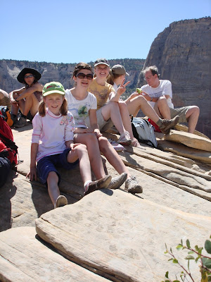 At the very top!
Today our main event was the 2 1/2 mile climb to Angels Landing, one of the most famous hikes in the park. A fairly tame 2 mile/1000 ft elevation gain hike with some cool switchbacks, then a jaw-dropping half-mile/500 ft gain scramble to the top of Angels Landing. This last half mile of trail sits atop a narrow sandstone rib with sheer cliffs to the valley floor on both sides.
 That is what we will be on top of in a couple hours - the trail climbs up from the left
Carlynn stayed behind at the motel, a little bruised and battered from our slot canyon trip yesterday. Jess, Sarah, Mel, and I started about 9:30 am, a little later than I would have liked, but the first set of switchbacks into Refrigerator Canyon was still in the shade. In the picture below, you can see the section of the trail carved into the sheer face of the cliff, a little below the section of blue sky in the photo. But this is the tame part of this trail!
 The trail up to Refridgerator Canyon
 This is the section of trail carved out of the cliff that you can see in the previous photo
After a short hike in the coolness of Refrigerator Canyon, you climb up a series of switchbacks known as Walter's Wiggles on the way to Scout Lookout and the start of the interesting part of the trail. Sarah ran from here to the parking lot on the way down - way too much energy.
 Looking down Walter's Wiggles
At the top of Walter's Wiggles there is a wonderful lookout where the faint of heart can see a great view and turn around the way they came. We weren't the faint of heart, and started on the final part of the trail. Shortly after this, we encountered a teen-age girl crying and clinging to a small tree (literally) in a wide area of the trail. A family member was with her, and another family member further up the trail was yelling back asking how "tree girl" was doing (insensitive younger brother, obviously). The poor girl was petrified, and you can see why with sheer drops on both sides of the trail.
The hike is easily done unless you are freaked by heights, then don't even think about it. In one short section the trail is no more than 3 feet wide with the cliffs on either side. In other places you have to scramble across angled sandstone faces which end ten or twenty feet below you in a sheer cliff. Jessica went ahead because she was "a little scared" and didn't want to freak out Melinda. Sarah looked for cliffs she could hang her feet over. Melinda was a trooper, hanging onto the chains and climbing up a trail where in many places you were a trip and a short tumble away from the most exciting (and last) few seconds of your life.
From the top you have the most amazing view up and down Zion Canyon to the river far below. After sitting and enjoying the top of the world feeling, we headed back down. I thought going down would be a lot scarier because instead of facing in towards the rock as you climb, you are facing out and can fully appreciate the exposure of the trail at the top of the cliffs. But for some reason it wasn't. The only bad part was that I hiked ahead of Melinda so I could help her down where needed, and it was a little creepy with her behind me on a lot of the trail where I couldn't watch her all the time and where a mistep without hanging onto the chain could send her tumbling into oblivion. OK, it maybe wasn't as bad as that sounds, but when you are a parent, you worry a little more. The lower part of the trail was in the sun, and it was hot, but the cool river waited at the bottom to soothe tired feet. As we sat and looked back up from the valley floor towards the top of Angels Landing, we realized how incredible that trail really is. A must do.
 The start of the "interesting" part of the trail
 Yes, that is 1000 feet straight down, Sarah, you don't need to get any closer!
 The trail cuts across the face of the cliff and climbs up the ridge in the backround
 At a narrow part of the trail (that is a cliff behind me and just to Sarah's right)
 Climbing the ridge to Angels Landing
 Don't show this one to Mom
 Looking back down the trail, which is at the top of the cliffs in the backround
 The last climb up to the top of Angels Landing
 The view up-canyon from near the top (1500 ft cliff to Jessica's left)
 Sarah was even a little bit creeped by hanging her feet over 1500 ft of nothingness
 At the very top!
Subscribe to:
Posts (Atom)